Live Blog - Tue, Mar 14, 2017 v2
Refresh
11:58 p.m.#
Toledo Express Airport
Mar 14, 2017 11:52 pm
Weather : Fair
Temperature : 14 F
Humidity : 56%
Wind Speed : WNW 7 mph
Barometer : 30.17 in
Dewpoint: 1 F
Visibility : 10.00 statute miles
Wind Chill : 4 F
Berkshire Eagle - In bull's-eye of the blizzard, Berkshires taking a hit
Boston NWS data:
Boston NWS tweets:
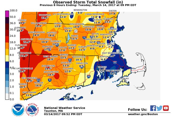
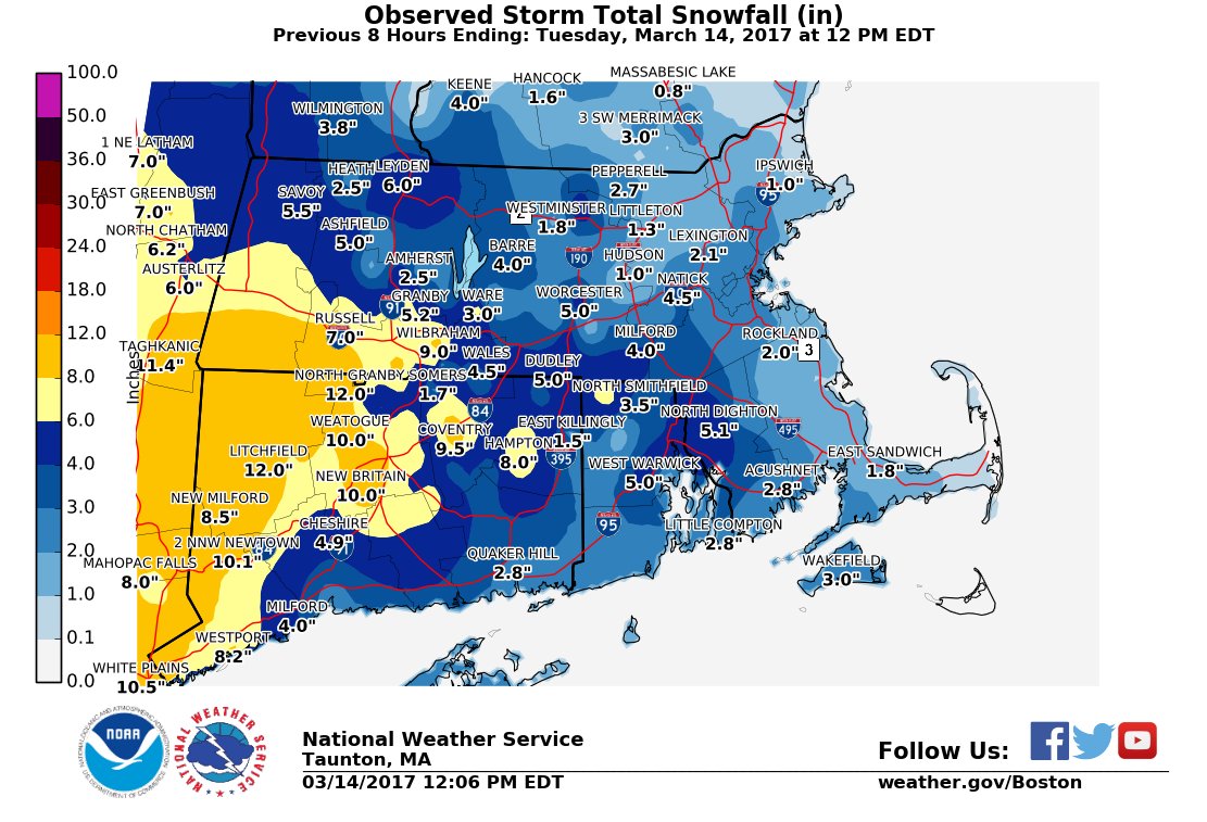
The highest snowfall amounts received so far in SNE were Granville at 21.5" and 20.0" in Huntington. Both locations in far western MA.
Latest snowfall map. A general 8 to 18" of snow fell northwest of a Boston to Providence line.
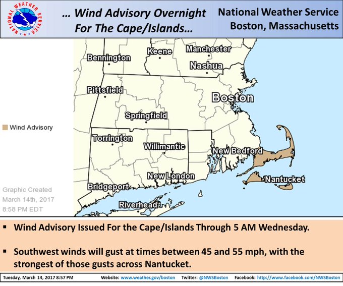
[905 PM] Wind Advisory issued through 5 AM Wednesday morning for the Cape/Islands. Southwest wind gusts between 45 and 55 mph expected.
Logan has 6.6 inches today
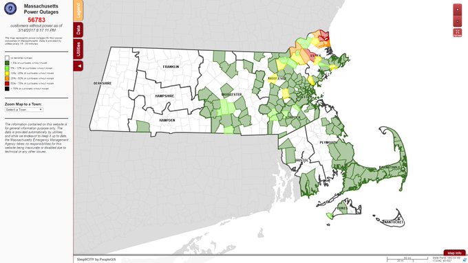
[Power Outages] As of 830 pm, still over 55,000 customers without power focused in northeast MA where 50-70 mph wind gusts occurred earlier.
5:25 p.m.#
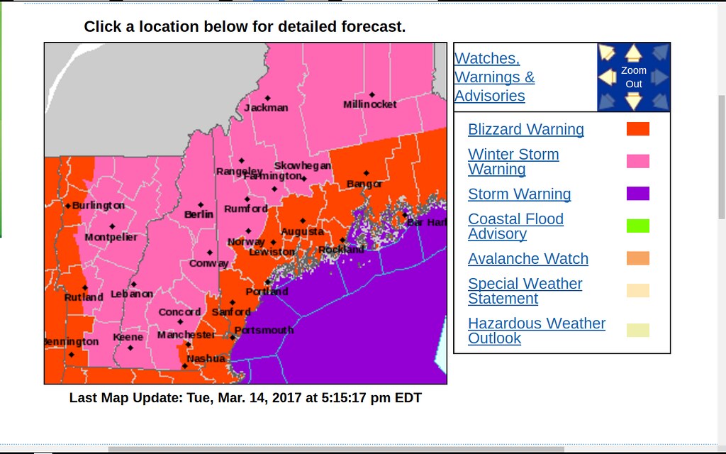
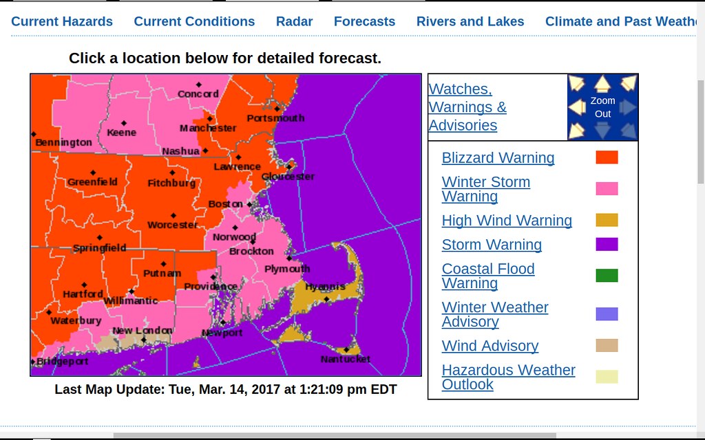
NWS Statements for Maine areas:
Warnings and advisories:
Bar Harbor, ME conditions
Location: Bar Harbor, Hancock County-Bar Harbor Airport (KBHB)
Weather: Heavy Snow, Freezing Fog, and Breezy
Temperature: 28 F
Humidity: 96%
Wind Speed: NE 21 G 31 mph
Barometer: 29.68 in (1005.5 mb)
Dewpoint: 27°F (-3°C)
Visibility: 0.25 mi
Wind Chill: 14°F (-10°C)
Last update: 14 Mar 4:56 pm EDT
5:10 p.m.#
Raining in Boston as of 5:00 p.m.
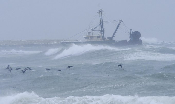
3:35 p.m. Cape Cod Times tweet
Photo gallery from today's crazy nor'easter
Photo of ocean, small boat, and birds
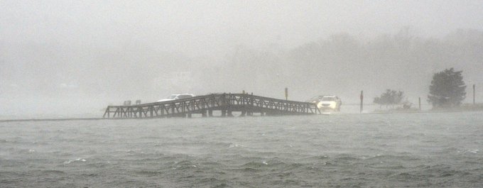
3:23 p.m. tweet by someone else:
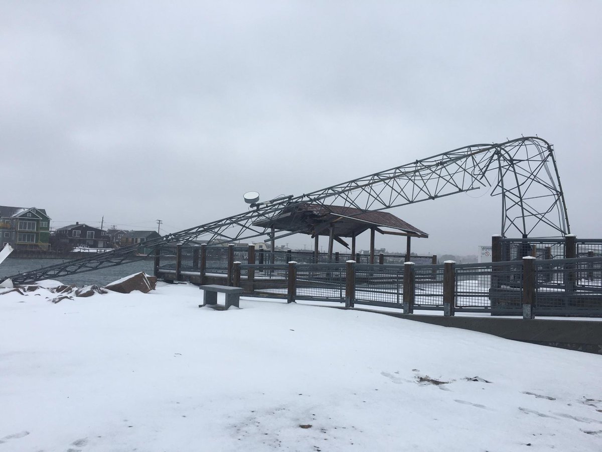
Sandwich Boardwalk is under water
Photo of Sandwich Boardwalk under water
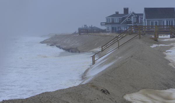
1:47 p.m. tweet
High tide bangs away at the latest sand ridge protecting Town Neck Beach homes
Photo of high tide at Town Neck Beach
Berkshire Eagle tweets that point to videos:
YouTube video : The March 14 blizzard renders the Berkshires in near white-out conditions
YouTube video : Pittsfield skyline in blizzard time lapse.
BerkshireEagle
5:05 p.m.#
Sunny, breezy, chilly day in Toledo. Some snow melted.
Toledo Express Airport:
Mar 14, 2017 4:52 pm
Weather : A Few Clouds
Temperature : 22 F
Humidity : 42%
Wind Speed : NW 17 mph - Gust 28 mph
Barometer : 30.15 in
Dewpoint: 2 F
Visibility : 10.00 statute miles
Wind Chill : 8 F
Toledo forecast
Last Update: Mar 14, 2017 3:55 pm
Tonight: Partly cloudy, with a low around 12. Wind chill values as low as -1. Northwest wind 10 to 17 mph.
Wednesday: Mostly sunny, with a high near 27. Wind chill values as low as -3. Northwest wind 14 to 17 mph.
Wednesday Night: Mostly cloudy, with a low around 17. West wind 11 to 14 mph.
Thursday: Mostly sunny, with a high near 37. West wind 8 to 13 mph.
Thursday Night: Partly cloudy, with a low around 25. Southwest wind 6 to 9 mph.
Friday: Snow likely, possibly mixed with freezing rain between 9am and 3pm, then rain. High near 42. Chance of precipitation is 80%. Little or no ice accumulation expected. New snow accumulation of less than one inch possible.
4:58 p.m.#
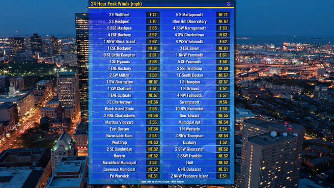
Boston Globe - Parts of Mass. are getting nearly hurricane-level winds
On Cape Cod, winds blowing at 72 mph were recorded in Wellfleet around 2 p.m. — just 2 mph short of hurricane force, according to the National Weather Service.
Rockport saw winds at 70 mph; Mattapoisett saw 71 mph; and the Blue Hill Observatory in Milton saw speeds of 67 mph. Many Boston areas — including Cambridge, Charlestown, and South and East Boston — saw winds in the mid-50 mph range.
4:03 p.m. BG twee
Western Mass may see up to 30 inches of snow, while less is expected in eastern and southeastern parts of the state
BG story: Along the coast, residents keep wary eye on the sea
4:50 p.m.#
Tweets from the Boston NWS:
Wellfleet, MA 79mph gust at 305PM. That is hurricane force.
Here is a snap shot of some of the wind gusts that has occurred across southern New England: (image link)
At 210PM a 72mph gust at Wellfleet, MA. 2mph short of hurricane force.
Worcester, MA has verified an official Blizzard. They have had blizzard conditions since 10:30AM.
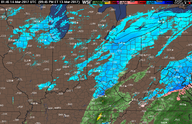
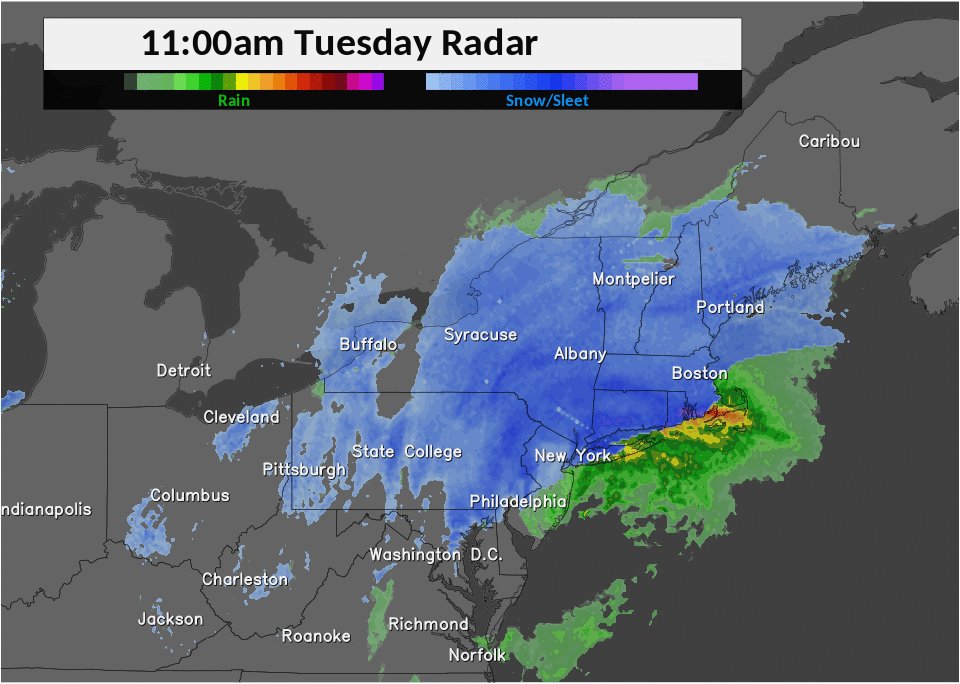
Here is the latest radar from over the past few hours. You can see this storm impacting locations from Pennsylvania all the way to Maine.
Radar image from the past few hours
1:49 p.m.#
Test of this page through 1:35 p.m.
https://www.webpagetest.org/result/170314_3W_14CP
wren.soupmode.com/2017/03/14/live-blog-tue-mar-14-2017.html
From: Dulles, VA - Chrome - Cable
3/14/2017, 1:47:59 PM
First View Fully Loaded:
1.426 seconds
11 requests
547 KB
Cost: $$
Embedding small images can add up quickly. For the downloaded bytes, 98.4% or 526 KB were for images. 1.6% or 8.6 KB were for HTML.
This page still loads in under 2 seconds for a fast connection. I need to test for a 3G simulated connection.
It might be best not to embed even small images and stick with providing only links to small and larger versions of each image.
A cell phone user on a slow connection might not want to view the large image, therefore provide a link to the small version too. And keep content on the live blog page only as text.
But even the amount of text needs to be kept small enough to make the page load quickly. A large blob of text can be a problem too.
That's why I think that frequently updated live blog pages need to be broken or separated each hour. The current hour would be the main live blog link. But each hour's content would be "archived" into its own page with its own unique URL.
If every hour is too frequent, then split the pages every three hours, depending upon the volume of posts.
1:35 p.m.#
Boston NWS Page:
http://www.weather.gov/box
Headlines:
Warnings and advisories:
1:25 p.m.#
The last update to the Boston Globe's live blog, or whatever it's called, occurred at 10:03 a.m.
1:18 p.m.#
12:24 p.m. tweet by NWS Boston
[Noon] Here is the current snowfall totals across southern New England. More detailed list can be found here
Image of Noontime snowfall totals
8 to 12 inches in western CT and southwestern MA.
1:15 p.m.#
11:48 a.m. tweet by Narragansett EMA
The snow might have stopped for the moment but the winds are very dangerous! They took down this wind turbine in Point Judith.
Photo of downed small wind turbine
1:12 p.m.#
48,000 customers without power in Mass.
Winds need to be less than 35 mph for crews to work safely.
1:04 p.m.#
WBZ reported now that power outages in Mass numbered 44,000. 60 to 90 minutes ago, the numbers went from hardly any to 7,000 and then 10,000, and then over 20,000. Shooting up rapidly due to increasing winds and due to some areas receiving heavy wet snow, combined with strong winds.
Within the past hour, I believe someone reported that Stockbridge, MA, located at the west end of Mass, reported 10 inches of snow accumulation.
1:00 p.m.#
Sunny day in Toledo with a few scattered small cumulus clouds dotting the vivid blue sky. Our midday temps were in the mid 20s, but since the March sun is higher and more intense than in our sunshine in December and January, the snow is melting, especially on sidewalks and roads. Brisk winds this afternoon in open areas pushed wind chills into the single digits.
Toledo Express Airport:
Mar 14, 2017 12:52 pm
Weather : A Few Clouds and Breezy
Temperature : 22 F
Humidity : 52%
Wind Speed : N 21 mph - Gust 29 mph
Barometer : 30.16 in
Dewpoint: 7 F
Visibility : 10.00 statute miles
Wind Chill : 7 F
12:42 p.m.#
Twitter feeds that I'm occasionally checking today:
- https://mobile.twitter.com/NWSBoston
- https://mobile.twitter.com/BostonGlobe
- https://mobile.twitter.com/capecodtimes
- https://mobile.twitter.com/BerkshireEagle
- https://mobile.twitter.com/DailyHampGaz
- https://mobile.twitter.com/WMassNews
- https://mobile.twitter.com/TheNewtownBee
11:38 a.m. tweet by the Daily Hampton Gazette
Much of the Pioneer Valley is closed today. How are you getting by?
DHG story link, contained within the tweet: Snow burying Valley, blizzard warning in effect
10:57 a.m. tweet from today, regarding the weather in eastern Massachusetts.
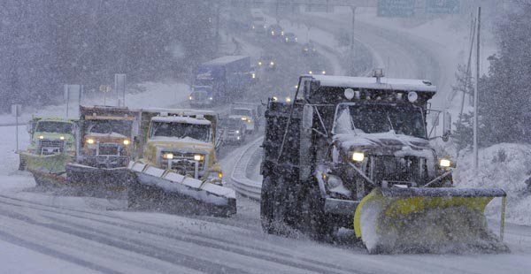
A snow plow quartet works to clear the Sagamore Bridge approach as heavy wet snow falls fast and furious on the Upper Cape.
7:00 a.m. tweet by the Berkshire Eagle
18-24 inches of snow, 'extremely dangerous travel' expected in the Berkshires
Berkshire Eagle story link, contained within the tweet: Blizzard bears down on region; 18-24 inches of snow, 'extremely dangerous travel' expected
12:12 p.m.#
Embedding images for testing. Clicking on the images will produce a larger version.
Animated radar image from last last night, showing the rare lake effect snow event, occurring over northeastern Illinois.
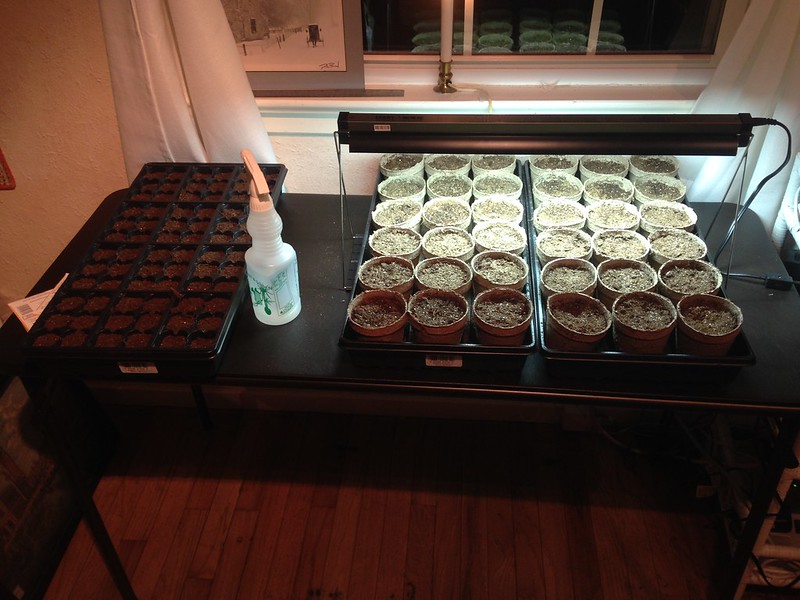
On Mar 3, 2017, I planted heirloom tomato seeds that I retrieved from my tomatoes that I started from seed last year. My seeds for last year's plants came from my Dad's 2015 tomatoes.
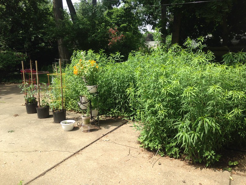
My small backyard garden from the summer of 2014.
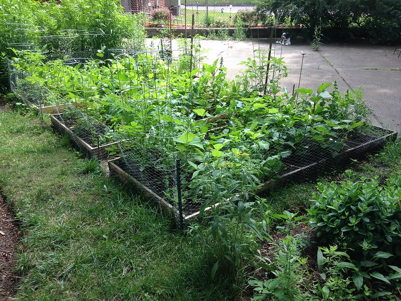
A dense wall of tall coreopsis plants in our backyard, during the summer of 2014.
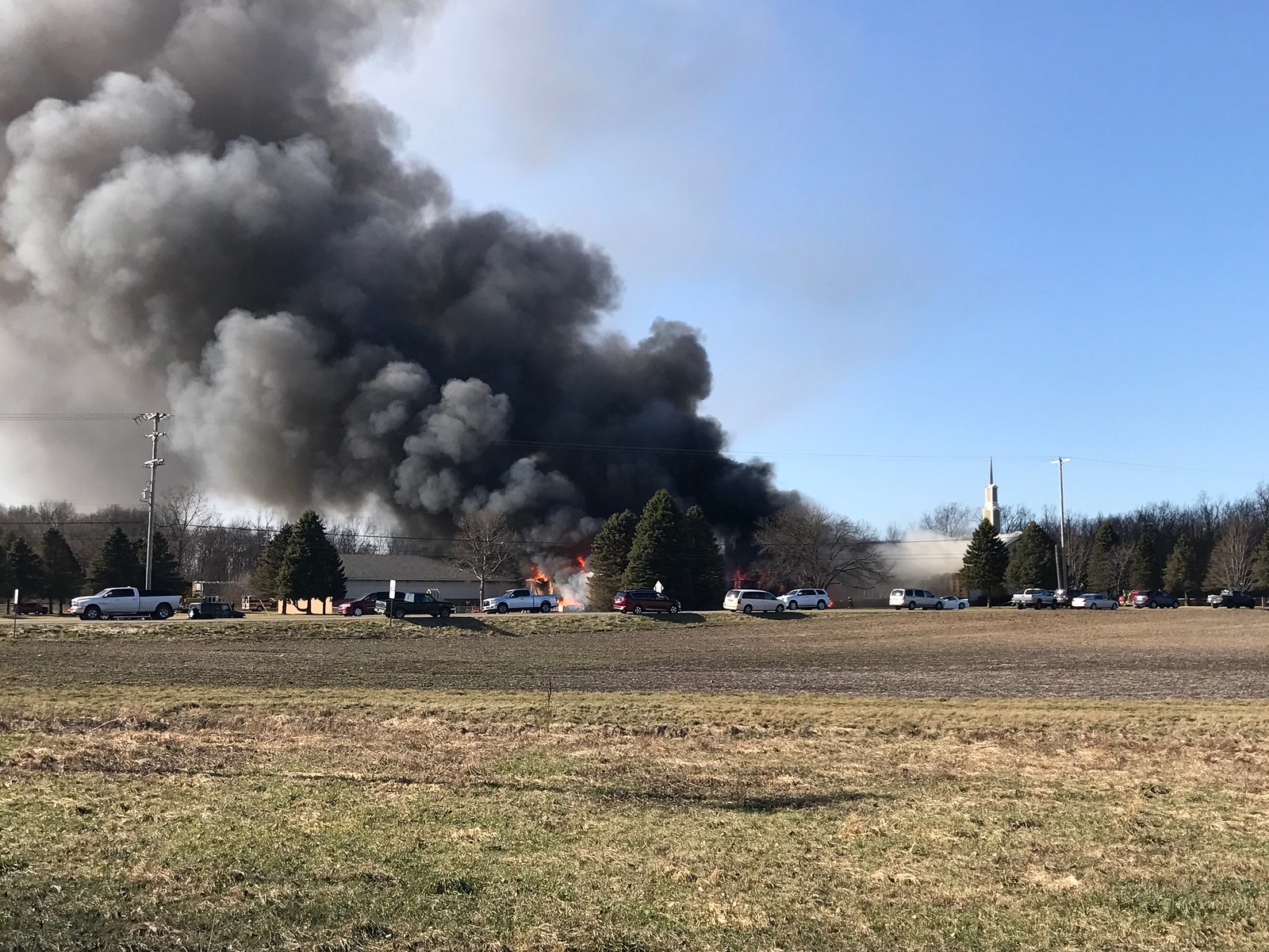
On Sat, Mar 4, 2017, my wife and I saw this church fire, near Erie, MI. We were leaving the Bay Creek store, located in downtown Erie when fire trucks went by. We saw the smoke in the distance, but not far away. We were drove to check it out, figuring it was a barn fire, but the density of the smoke increased as we approached.
Numerous fire departments responded. Over 20 fire-related trucks surrounded the church property, but the firemen could do little to save it. Brisk winds fanned the flames. The congregation part of the church was destroyed. I watched the steeple topple and fall inside the church.
11:57 a.m.#
WebPageTest.org comparisons.
https://www.webpagetest.org/result/170314_X4_ZSY
www.bostonglobe.com/metro/2017/03/13/live-updates-major-march-snow-storm-hit-mass/PfN48igI9fovA5sjhv9FiM/story.html
From: Dulles, VA - Chrome - Cable
3/14/2017, 11:36:59 AM
First View Fully Loaded:
28.508 seconds
331 requests
6,635 KB downloaded
Cost = $$$$$ (max)
All are pathetic numbers. The media's war on the web. 331 requests !!! Over 6.5 megabytes of crapware downloaded !!! And nearly a half a minute to download everything over a fast connection. What about LTE or even 3G?
For that BG live blog page, which includes the main page and the embedded ScribbleLive data too, I think, 66% of the downloaded bytes or 4.3 mb were due to "image". 25% or 1.6 mb were for JavaScript. HTML represented 3.2% or about 210 KB, which is still large-ish for an HTML page.
Now for this page, prior to the 11:44 a.m. post.
https://www.webpagetest.org/result/170314_G8_ZYE
wren.soupmode.com/2017/03/14/live-blog-tue-mar-14-2017.html
From: Dulles, VA - Chrome - Cable
3/14/2017, 11:40:32 AM
First View Fully Loaded:
0.346 seconds
2 requests
6 KB downloaded
Cost = $
I have no images embedded, yet, in this page. I'll add some test small images that contain links to the larger versions. I'll embed some tweets my way.
11:44 a.m.#
Also, the Boston Globe's version of a live blog that relies on embedding a service from ScribbleLive means that the ScribbleLive section has its own vertical scrollbars. And of course, the main web page or article page has its own vertical scrollbars.
It looks odd. It's a clunky UI/UX. And I'll have to double-check, but I think that the ScribbleLive app or whatever it's called is hogging CPU resources.
It seems unnecessary and overkill. BG is embedding too much from social media, and these social media embed posts contain too many large-ish images.
In my opinion, the live blog for a breaking news event should focus on text info, and the page should be as lightweight and as fast-loading as possible.
Break the live blog page up into small pieces if necessary. If not hourly versions, then maybe create a new page every three to six hours with links to the previous pages.
11:24 a.m.#
As of sunrise this morning, only 1 to 2 inches of snow fell over the Toledo area, accumulating more on lawns than on sidewalks. I don't think that any snow fell overnight. The forecast was a bust.
The snow fell yesterday mainly from sunrise to sunset. Most of the time, the snowflakes were fine-grain and powdery. Stiff east winds yesterday moved the snow sideways at times. It looked like winter.
This morning's weather was sunny with temps in the mid to upper teens. A light to moderate wind produced wind chill temps in the single digits. The landscape looked good this morning with the snow sparkling in the sunshine.
Today will be breezy with sunshine and temps in the mid 20s. Tonight/tomorrow morning, temps will dip to 10 to 15 degrees with wind chills around zero.
Ahead of yesterday's snow, the Cle NWS forecasts varied on Saturday, Sunday, and early Monday morning, predicting 2 to 4 inches, 3 to 5 inches, and 4 to 6 inches. The amounts increased as we moved closer to Monday, indicating that we would receive a decent snowfall for March. But that didn't occur.
This morning, I was outside from approx 7:20 a.m. to 9:00 a.m. I cleared paths in the backyard for bird seed. I shoveled the front walks.
Since the snow was lightweight and powdery, and since the snow accumulated only around one inch on the sidewalks, I could have used a Carolina Shovel, which is a broom.
I walked barney for a med-long stroll. He seemed to slow down on the back nine, which was unusual. Hopefully, he's okay. He's still wearing his winter coat. He has an appointment tomorrow at Clip 'N Dales, and I will have him shaved for his summer look. I typically wait until early April.
While outside this morning, I took photos.
The low sun became visible around 8:00 a.m. Sky was mostly clear. Some cirrocumulus clouds existed. Also some low, stratocumulus clouds existed at the eastern horizon.
The sky contained pastel colors, prior to the sun popping above the horizon/houses/trees.
With the sun up, yellowish light struck houses, top half of oak trees, and the snow. But blueish shadows existed on the same areas. It was a nice mix of sun and shadows.
Temps this morning were in the mid to upper teens with a light to moderate wind, producing wind chills in the single digits. The brisk air felt good on the cheeks.
I'm always impressed by the early morning and evening light, washing across a snow-covered landscape.
11:20 a.m.#
Posted over an hour ago at the Boston Globe live blog page.
Mar 14 2017 10:03 AM
What you need to know about today's winter storm
- Snowfall will peak around 10 a.m.
- Most snow will fall between 10 a.m. and 3 p.m.
- 2-4 inches per hour expected to fall in that time
- Snow emergency and parking ban declared in Boston
- 6 to 12 inches expected in Boston, more outside I-495
- Wind gusts could reach as high as 65 miles per hour along the coast
Stories from Western Mass:
- Berkshire Eagle - Blizzard bears down on region; 18-24 inches of snow, 'extremely dangerous travel' expected
- Daily Hampshire Gazette - Snow burying Valley, blizzard warning in effect
10:59 a.m.#
Over the web, I'm listening to WBZ in Boston for weather news as a large storm moves up along the East Coast.
I'm also monitoring the Boston Globe's live blog, which, unfortunately, relies on using and embedding a service by ScribbleLive. Naturally, it requires JavaScript to be enabled.
Other media orgs, such as the Guardian, need JavaScript enabled to make their live blogs work, which bizarre.
Simple, lo-fi refresh options exist that do not require JavaScript.
- The old HTML meta refresh works without JavaScript. It's old-school and a little clunky, since the page will redraw while a reader is viewing it. Example: Place between the opening and closing
<head>tags to refresh page after 5 seconds:<meta http-equiv="refresh" content="5"> - The web page can provide a link to itself that tells users to click to refresh.
- And obviously, users can refresh by typing
F-5or by clicking the browser's refresh button.
At the moment, I'm using options 2 and 3 for this page.
Live blog pages can get heavy. That's not because of a long page of text, but because unnecessary large images are embedded, and now media orgs copy and paste the embed code, provided by social media orgs. Some embed code requires JavaScript to be enabled.
Text from tweets could be copied and a link provided to the tweet. Small images should be embedded with a link to a larger version. Text and links should be used for Instagram posts, instead of embedding the image and the JavaScript-required code.
If it's a localized major news event, it's possible that some users may be accessing the live blog page over a slow cell connection. It could be frustratingly slow to view a bloated live blog page when the user only needs some text info.
Link to the large images, videos, and social media posts.